C-ITS Roadworks Warning goes operational
C-ITS Road Side Units (RSUs) allow the road to communicate with vehicles and open new ways to optimize traffic and raise safety. The joint C-ITS corridor from Rotterdam to Vienna marks the beginning of the C-ITS RSU deployment in Austria. Even though ASFINAG has already equipped other regions and plans to achieve full C-ITS network coverage by 2025, the so-called “west corridor” is where operational use-cases are first deployed. This road segment spans from the German to the Hungarian border and constitutes the Austrian part of the joint C-ITS corridor. The first use-case that is fully operational is roadworks warning (RWW).

Accidents related to roadworks scenarios are common and a big concern for every infrastructure operator. Beside the risk for road users, they threaten both personnel and equipment at the roadworks site. Around 10-15% of roadworks trailers get damaged or destroyed every year on ASFINAG’s motorway network. To send the warning to vehicles, C-ITS messages are used. They contain an event type (e.g. roadworks ahead) and relevant GNSS information. The event position is the relevant spot where the defined event starts or occurs. Considering the RWW, this would be for example the first traffic cone placed to gradually close a lane. If the vehicle, which receives the message, displays a distance together with the warning (e.g. Roadworks in 100m), the distance from the vehicle to the event position is used. Therefore, highly accurate GNSS data for the event position is needed. A detection zone helps the vehicle to determine if the warning message is relevant by comparing the trajectory provided in the message against its own GNSS-based vehicle trajectory. The relevance zone shows the geographical extent of the roadworks and ends when there are no more obstacles on the road. To collect the GNSS information, the project BBO (roadworks equipment localization) was put into practise.

Basically, the BBO project includes GNSS devices mounted on cones or mobile safety trailers, as well as a tablet-optimized web application. The GNSS information is used by the C-ITS backend to create the message which is later transmitted by relevant RSUs. The GNSS mounted equipment (BBO devices) is placed the same way as in every roadworks and sends its position periodically without user intervention.
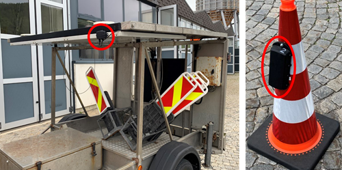
To make sure, that the GNSS data is accurate enough, a quality control step was implemented. With a web application (BBO app), workers can check the location visually and add an accurate starting point to a digital representation of the roadworks. It is important to mention, that employees can interact with the BBO app in a safe distance as the GNSS signal is sent out from the BBO devices, which are placed in the danger zone. Oncen the roadworks is completed, the staff on-site can end the roadworks with the app, or the system detects the end of the roadworks automatically with a deviation in the GNSS data once the sender is replaced. This ensures data quality and exact message duration for sent messages.
Contact Information
Wolfgang Gritzner
Project Manager C-ITS / CCAD
ASFINAG Maut Service GmbH
wolfgang.gritzner@asfinag.at


